[tab: Storms]
- Mon, 09 Jun 2025 09:55:03 +0000: SPC Severe Thunderstorm Watch 400 Status Reports - SPC Forecast Products
WW 0400 Status Updates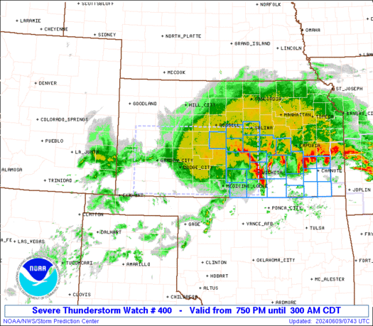
STATUS REPORT ON WW 400

SEVERE WEATHER THREAT CONTINUES RIGHT OF A LINE FROM 35 W TPL TO
35 NNW CLL TO 30 WNW UTS TO 35 SSE LFK TO 25 SSW POE TO 45 ESE
POE TO 35 SE ESF.

..BENTLEY..06/09/25

ATTN...WFO...LCH...FWD...HGX...EWX...


STATUS REPORT FOR WS 400

SEVERE WEATHER THREAT CONTINUES FOR THE FOLLOWING AREAS

LAC001-003-009-011-019-023-039-053-055-097-113-091040-

LA
.    LOUISIANA PARISHES INCLUDED ARE

ACADIA               ALLEN               AVOYELLES
BEAUREGARD           CALCASIEU           CAMERON
EVANGELINE           JEFFERSON DAVIS     LAFAYETTE
ST. LANDRY           VERMILION


TXC027-039-041-051-053-071-157-167-185-199-201-241-245-287-291-
313-331-339-351-361-373-407-457-471-473-477-491-091040-

TX
.    TEXAS COUNTIES INCLUDED ARE

BELL                 BRAZORIA            BRAZOS
BURLESON             BURNET              CHAMBERS
FORT BEND            GALVESTON           GRIMES
HARDIN               HARRIS              JASPER
JEFFERSON            LEE                 LIBERTY
MADISON              MILAM               MONTGOMERY
NEWTON               ORANGE              POLK
Read more - Mon, 09 Jun 2025 09:55:03 +0000: SPC Severe Thunderstorm Watch 400 - SPC Forecast Products
WW 400 SEVERE TSTM LA TX CW 090650Z - 091200ZURGENT - IMMEDIATE BROADCAST REQUESTED Severe Thunderstorm Watch Number 400 NWS Storm Prediction Center Norman OK 150 AM CDT Mon Jun 9 2025 The NWS Storm Prediction Center has issued a * Severe Thunderstorm Watch for portions of Southwest Louisiana Southeast and Central Texas Coastal Waters * Effective this Monday morning from 150 AM until 700 AM CDT. * Primary threats include... Scattered damaging winds and isolated significant gusts to 75 mph possible Isolated very large hail events to 2 inches in diameter possible SUMMARY...A line of intense thunderstorms will sag southward overnight across the watch area, posing a risk of damaging wind gusts and some hail. The severe thunderstorm watch area is approximately along and 45 statute miles north and south of a line from 35 miles north northwest of Austin TX to 10 miles east northeast of Lafayette LA. For a complete depiction of the watch see the associated watch outline update (WOUS64 KWNS WOU0). PRECAUTIONARY/PREPAREDNESS ACTIONS... REMEMBER...A Severe Thunderstorm Watch means conditions are favorable for severe thunderstorms in and close to the watch area. Persons in these areas should be on the lookout for threatening weather conditions and listen for later statements and possible warnings. Severe thunderstorms can and occasionally do produce tornadoes. && OTHER WATCH INFORMATION...CONTINUE...WW 399... AVIATION...A few severe thunderstorms with hail surface and aloft to 2 inches. Extreme turbulence and surface wind gusts to 65 knots. A few cumulonimbi with maximum tops to 500. Mean storm motion vector 28035. ...HartRead more - Mon, 09 Jun 2025 09:54:03 +0000: SPC MD 1219 - SPC Forecast Products
MD 1219 CONCERNING SEVERE THUNDERSTORM WATCH 400... FOR PORTIONS OF CENTRAL TO SOUTHEAST TEXAS
Mesoscale Discussion 1219
NWS Storm Prediction Center Norman OK
0413 AM CDT Mon Jun 09 2025

Areas affected...portions of central to southeast Texas

Concerning...Severe Thunderstorm Watch 400...

Valid 090913Z - 091045Z

The severe weather threat for Severe Thunderstorm Watch 400
continues.

SUMMARY...An isolated severe wind threat will persist for the next 1
to 2 hours across parts of central Texas into southeast Texas.

DISCUSSION...Convection has mostly weakened along the southward
moving outflow boundary from southeast Texas into southern
Louisiana. On the western periphery of the outflow boundary, across
central Texas, stronger storms have persisted amid stronger
instability and steeper mid-level lapse rates. Some stronger inbound
velocities are present from the KGRK WSR-88D which could result in
isolated severe wind reports. While additional strengthening of
these storms appears unlikely, the environment should support some
maintenance of ongoing storms with a continued threat for isolated
severe wind gusts.

Farther east along the the outflow boundary, additional convection
has started to develop across southeast Texas and southwest
Louisiana. It is unclear whether these storms will be severe, but
watch 400 will be maintained across this region despite the warm
700mb temperatures, in case a few severe storms develop. Severe wind
gusts from wet microbursts will likely be the primary threat from
this activity.

..Bentley.. 06/09/2025

...Please see www.spc.noaa.gov for graphic product...

ATTN...WFO...LCH...HGX...FWD...EWX...

LAT...LON   31529782 31369682 30899480 30939395 30989341 30719293
            30299299 30089341 29949526 30049642 30219740 30359778
            30569814 31049842 31529782

MOST PROBABLE PEAK WIND GUST...55-70 MPH
MOST PROBABLE PEAK HAIL SIZE...UP TO 1.25 IN
Read more - Mon, 09 Jun 2025 08:50:06 +0000: SPC Jun 9, 2025 Day 4-8 Severe Weather Outlook - SPC Forecast Products
Day 4-8 Outlook
Day 4-8 Convective Outlook
NWS Storm Prediction Center Norman OK
0347 AM CDT Mon Jun 09 2025

Valid 121200Z - 171200Z

...DISCUSSION...
Guidance remains supportive of a more active pattern across the
northern High Plains to the Upper Midwest. GEFS-based ML guidance
from SPC and NSSL depict mesoscale areas of 15 percent
probabilities, centered on eastern MT to the Dakotas. While
predictability for a specific day remains too low, the signal exists
for increasing potential during the weekend to early next week.

The initial low-amplitude shortwave trough over WY/eastern MT at 12Z
Thursday is progged to dampen as it moves east into the Upper
Midwest. An area-of-interest is evident over western SD and the NE
Panhandle on D4/Thursday afternoon, but a favorable buoyancy/shear
combination is too spatially confined for a 15 percent highlight.

A broad swath of moderate to strong mid-level southwesterlies may
persist for multiple days across the Northwest, downstream of a
large-scale trough near the West Coast. At the same time, the
expansive buoyancy plume over the central states should increase
northwestward, building higher CAPE into the northern High Plains
this weekend. Still, poor predictability persists with the
spatiotemporal details of individual shortwave impulses that may
support daily severe threats on D6-8/Saturday-Monday.
Read more - Mon, 09 Jun 2025 07:32:06 +0000: SPC Jun 9, 2025 0730 UTC Day 3 Severe Thunderstorm Outlook - SPC Forecast Products
SPC 0730Z Day 3 Outlook
Day 3 Convective Outlook
NWS Storm Prediction Center Norman OK
0230 AM CDT Mon Jun 09 2025

Valid 111200Z - 121200Z

...THERE IS A MARGINAL RISK OF SEVERE THUNDERSTORMS IN PARTS OF THE
CENTRAL AND WESTERN STATES...

...SUMMARY...
Isolated severe thunderstorms are possible over parts of the
Northwest and Intermountain West, the Corn Belt, and southern Texas.

...Northwest/Intermountain West...
A low-amplitude shortwave trough will progress across the northern
Great Basin towards the WY Rockies through 12Z Thursday. Its
attendant belt of enhanced mid-level westerlies should remain rather
confined, likely centered on southeast ID/northern UT during late
afternoon Wednesday. Boundary-layer moisture will remain modest,
contributing to mainly weak buoyancy. Scattered thunderstorms are
likely during the afternoon Wednesday with a broad region of at
least low-probability severe wind/hail across parts of ID/MT/UT/WY.

...Corn Belt...
A west/east-oriented baroclinic zone is expected to strengthen by
Wednesday afternoon as richer low-level moisture advects north
across the central states and surface ridging noses south across MN
in the wake of a shortwave trough over eastern ON. A confined
corridor of moderate surface-based buoyancy may develop south of the
front, but will quickly weaken in the cooler/drier stable air mass
to the north. Mid-level westerlies will similarly have a gradient
across the boundary, stronger north and weaker south. Overall setup
could support isolated severe hail/wind within a confined corridor
from late afternoon into evening on Wednesday.

...Southern/central TX...
A low-confidence forecast is anticipated as a low-amplitude
shortwave trough stalls on Wednesday. A belt of modestly enhanced
mid-level flow is anticipated ahead of it with southwesterlies, and
behind it with northwesterlies. Convective evolution has large
spread across guidance and overall appears nebulous given the
synoptic pattern. Have delineated a low-probability severe risk
mainly across the southern to central parts of TX where pockets of
greater destabilization, coincident with modest deep-layer shear,
may be realized.

..Grams.. 06/09/2025
Read more
[tab:Hurricanes]
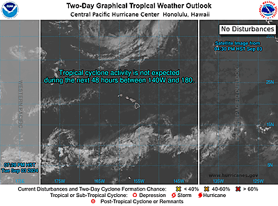
- Mon, 09 Jun 2025 08:46:18 +0000: NHC Eastern North Pacific Outlook - National Hurricane Center Graphical Tropical Weather Outlooks


ZCZC MIATWOEP ALL
TTAA00 KNHC DDHHMM
Tropical Weather Outlook
NWS National Hurricane Center Miami FL
1100 PM PDT Sun Jun 8 2025
For the eastern and central North Pacific east of 180 longitude:
Active Systems:
The National Hurricane Center is issuing advisories on Tropical
Storm Barbara, and on Tropical Storm Cosme, both located in the
eastern Pacific basin off the coast of southwestern Mexico.
1. South of Southern Mexico:
An area of low pressure is forecast to develop later this week south
of southern Mexico. Environmental conditions appear conducive for
some gradual development of this system, and a tropical depression
could form late this week or over the weekend.
* Formation chance through 48 hours...low...near 0 percent.
* Formation chance through 7 days...medium...60 percent.
Public Advisories on Tropical Storm Barbara are issued under WMO
header WTPZ32 KNHC and under AWIPS header MIATCPEP2.
Forecast/Advisories on Tropical Storm Barbara are issued
under WMO header WTPZ22 KNHC and under AWIPS header MIATCMEP2.
Public Advisories on Tropical Storm Cosme are issued under
WMO header WTPZ33 KNHC and under AWIPS header MIATCPEP3.
Forecast/Advisories on Tropical Storm Cosme are issued under
WMO header WTPZ23 KNHC and under AWIPS header MIATCMEP3.
Forecaster Hagen - Mon, 09 Jun 2025 05:07:56 +0000: NHC Atlantic Outlook - National Hurricane Center Graphical Tropical Weather Outlooks


ZCZC MIATWOAT ALL
TTAA00 KNHC DDHHMM
Tropical Weather Outlook
NWS National Hurricane Center Miami FL
200 AM EDT Mon Jun 9 2025
For the North Atlantic...Caribbean Sea and the Gulf of America:
Tropical cyclone formation is not expected during the next 7 days.
$$
Forecaster Hagen
NNNN - Mon, 09 Jun 2025 05:06:21 +0000: CPHC Central North Pacific Outlook - National Hurricane Center Graphical Tropical Weather Outlooks
ZCZC HFOTWOCP ALL
TTAA00 PHFO DDHHMM
Tropical Weather Outlook
NWS Central Pacific Hurricane Center Honolulu HI
Issued by NWS National Hurricane Center Miami FL
800 PM HST Sun Jun 08 2025
For the central North Pacific...between 140W and 180W:
Active Systems:
The National Hurricane Center is issuing advisories on Tropical
Storm Barbara, and on Tropical Storm Cosme, both located in the
eastern Pacific basin off the coast of southwestern Mexico.
Tropical cyclone formation is not expected during the next 7 days.
Public Advisories on Tropical Storm Barbara are issued under WMO
header WTPZ32 KNHC and under AWIPS header MIATCPEP2.
Forecast/Advisories on Tropical Storm Barbara are issued
under WMO header WTPZ22 KNHC and under AWIPS header MIATCMEP2.
Public Advisories on Tropical Storm Cosme are issued under
WMO header WTPZ33 KNHC and under AWIPS header MIATCPEP3.
Forecast/Advisories on Tropical Storm Cosme are issued under
WMO header WTPZ23 KNHC and under AWIPS header MIATCMEP3.
Forecaster Hagen
[tab:Tsunamis]
- Fri, 06 Jun 2025 17:22:20 +0000: off the coast of northern Chile - Tsunami Information Statement Number 1
Category: Information
Bulletin Issue Time: 2025.06.06 17:22:20 UTC
Preliminary Magnitude: 6.5(Mwp)
Lat/Lon: -26.600 / -71.100
Affected Region: off the coast of northern Chile
Note: * There is no tsunami danger for the U.S. West Coast, British Columbia, or Alaska. * Based on earthquake information and historic tsunami records, the earthquake is not expected to generate a tsunami.
Definition: An information statement indicates that an earthquake has occurred, but does not pose a tsunami threat, or that a tsunami warning, advisory, or watch has been issued for another section of the ocean. View bulletin

[tab:Earthquakes]
[tab:Volcanoes]
[tab:Weather]
[tab:CDC]
[tab:NASA]
- Fri, 06 Jun 2025 22:53:41 +0000: Sols 4561-4562: Prepping to Drill at Altadena - NASA
Written by Conor Hayes, Graduate Student at York University Earth planning date: Wednesday, June 4, 2025 We are continuing to look for a suitable location to collect a drilled sample in this area. As you may recall from Monday’s plan, we performed a short “bump” of just under 4 meters (about 13 feet) hoping to […] - Fri, 06 Jun 2025 21:53:43 +0000: Searching for Ancient Rocks in the ‘Forlandet’ Flats - NASA
Written by Henry Manelski, Ph.D. student at Purdue University This week Perseverance continued its gradual descent into the relatively flat terrain outside of Jezero Crater. In this area, the science team expects to find rocks that could be among the oldest ever observed by the Perseverance rover — and perhaps any rover to have explored […] - Fri, 06 Jun 2025 20:58:59 +0000: Dr. Natasha Schatzman Receives Vertical Flight Society (VFS) Award - NASA
Dr. Natasha Schatzman Receives Vertical Flight Society (VFS) Award In May 2025, Dr. Natasha Schatzman, aerospace engineer in the Aeromechanics Office at NASA Ames Research Center, received the inaugural Alex M. Stoll Award from the Vertical Flight Society (VFS). This award honors a professional in the field of vertical flight who “demonstrates an exceptional commitment […] - Fri, 06 Jun 2025 18:02:54 +0000: Webb Sees Sombrero Galaxy in Near-Infrared - NASA
After capturing an image of the iconic Sombrero galaxy at mid-infrared wavelengths in late 2024, NASA’s James Webb Space Telescope has now followed up with an observation in the near-infrared. In the newest image, released on June 3, 2025, the Sombrero galaxy’s tightly packed group of stars at the galaxy’s center is illuminated while the dust in […] - Fri, 06 Jun 2025 17:20:52 +0000: NASA Mars Orbiter Captures Volcano Peeking Above Morning Cloud Tops - NASA
The 2001 Odyssey spacecraft captured a first-of-its-kind look at Arsia Mons, which dwarfs Earth’s tallest volcanoes. A new panorama from NASA’s 2001 Mars Odyssey orbiter shows one of the Red Planet’s biggest volcanoes, Arsia Mons, poking through a canopy of clouds just before dawn. Arsia Mons and two other volcanoes form what is known as […]
[tab:END] The remaining page content goes here and will appear BELOW the tabbed content container.
